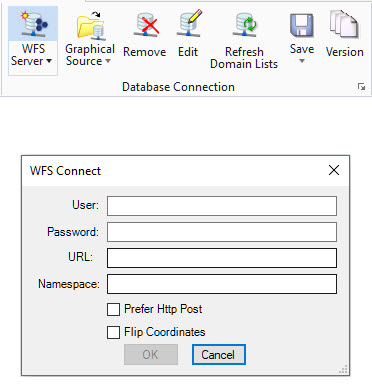
Connecting to WFS
The WFS Connect dialog is used to establish a connection to a WFS Server. It can be opened directly from the Database Connection ribbon group.
- Connection Name - The name for the graphical source
- Description - An optional description
- URL - URL of the WFS server
- Namespace - A separate namespace if defined by the service
- User - WFS Server User name
- Password - WFS Server password
- Prefer Http post - Default method for WFS requests is HTTP Get. Use this checkbox to enforce usage of Http Post. This may help to resolve issues during import
- Flip Coordinates - WFS 1.0.0 servers specify the axis order for geographic coordinates as longitude/latitude (X/Y). WFS 1.1.0 and 2.0.0 servers specify the axis order as latitude/longitude (Y/X). This may result in queried features being rotated or flipped. To avoid this, enable Flip Coordinates.
When defining a graphical source as a WFS connection in OpenCities Geospatial Administrator, the Build Connection dialog provides additional options.
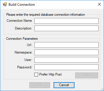
- User - WFS Server User name
- Password - WFS Server password
- URL - URL of the WFS server
- Namespace - A separate namespace if defined by the service
- Prefer Http post - Default method for WFS requests is HTTP Get. Use this checkbox to enforce usage of Http Post. This may help to resolve issues during import
See Working with WFS for more information.